


Tour N°2 - Tour de Mieussy

HG74250
User
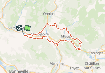

Length
32 km

Max alt
936 m

Uphill gradient
1105 m
Km-Effort
47 km

Min alt
502 m

Downhill gradient
1096 m
Boucle
Yes
Creation date :
2019-05-02 19:07:38.015
Updated on :
2020-01-04 17:29:01.494
3h00
Difficulty : Medium

FREE GPS app for hiking
 SityTrail
IGN / Geographical institutes
SityTrail Plus
The world is yours!
About
Trail Mountain bike of 32 km to be discovered at Auvergne-Rhône-Alpes, Upper Savoy, La Tour. This trail is proposed by HG74250.
Positioning
Country:
France
Region :
Auvergne-Rhône-Alpes
Department/Province :
Upper Savoy
Municipality :
La Tour
Location:
Unknown
Start:(Dec)
Start:(UTM)
300744 ; 5112602 (32T) N.
Comments